![](/images/other/stat-length.png)
![Trail On foot Kostomlaty pod Milešovkou - NS Březina - Photo](https://media.geolcdn.com/t/1900/400/52d21845-8dcd-4caf-8daa-efe170d09bc7.jpeg&format=pjpeg&maxdim=2)
NS Březina
SityTrail - itinéraires balisés pédestres
Tous les sentiers balisés d’Europe GUIDE+
![Length](/images/other/stat-length.png)
Length
7.1 km
![Max alt](https://static1.geolcdn.com/siteimages/upload/files/1508320355ic_sort_altitude_max_24dp.png)
Max alt
699 m
![Uphill gradient](https://static1.geolcdn.com/siteimages/upload/files/1508320355ic_sort_den_pos_24dp.png)
Uphill gradient
252 m
![Km-Effort](/images/other/stat-length.png)
Km-Effort
10.5 km
![Min alt](https://static1.geolcdn.com/siteimages/upload/files/1508320355ic_sort_altitude_min_24dp.png)
Min alt
502 m
![Downhill gradient](https://static1.geolcdn.com/siteimages/upload/files/1508320355ic_sort_den_neg_24dp.png)
Downhill gradient
255 m
![Boucle](https://static1.geolcdn.com/siteimages/upload/files/16400158638029165_repeat_loop_refresh_sync_direction_icon.png)
Boucle
Yes
Signpost
Creation date :
2025-02-06 23:46:32.661
Updated on :
2025-02-06 23:46:32.661
![On foot](https://static1.geolcdn.com/sitytour/trail-icons/100.png)
2h23
Difficulty : Easy
![Scan this QR Code to open this trail in the SityTrail application](https://capi.geolives.com/qq0zvz2zws4bq2lad0pu/sitytour/trails/4344283/qr.png?size=200)
FREE GPS app for hiking
About
Trail On foot of 7.1 km to be discovered at Northwest, Ústecký kraj, Kostomlaty pod Milešovkou. This trail is proposed by SityTrail - itinéraires balisés pédestres.
Description
Trail created by cz:KČT.
Positioning
Country:
Czech Republic
Region :
Northwest
Department/Province :
Ústecký kraj
Municipality :
Kostomlaty pod Milešovkou
Location:
Unknown
Start:(Dec)
Start:(UTM)
421116 ; 5599609 (33U) N.
Comments
Trails nearby
![Trail On foot Ústí nad Labem - [M] Modrý vycházkový okruh - Střížovický vrch - Photo](https://media.geolcdn.com/t/375/260/009e9caa-28f6-4b1e-9328-d158e5ef6640.jpeg&format=jpg&maxdim=2)
![On foot On foot](https://static1.geolcdn.com/sitytour/trail-icons/100.png)
[M] Modrý vycházkový okruh - Střížovický vrch
On foot
Easy
Ústí nad Labem,
Northwest,
Ústecký kraj,
Czech Republic
![](/images/other/stat-length.png)
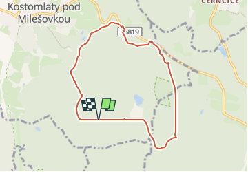
3.6 km | 5 km-effort
1h 8min
![](https://static1.geolcdn.com/siteimages/upload/files/16400158638029165_repeat_loop_refresh_sync_direction_icon.png)
Yes
![Trail On foot Dubí - [M] Okruh kolem Francouzského kamene - Photo](https://media.geolcdn.com/t/375/260/394e4c19-d604-4c61-b996-a104413a844a.jpeg&format=jpg&maxdim=2)
![On foot On foot](https://static1.geolcdn.com/sitytour/trail-icons/100.png)
[M] Okruh kolem Francouzského kamene
On foot
Easy
Dubí,
Northwest,
Ústecký kraj,
Czech Republic
![](/images/other/stat-length.png)
5.5 km | 8.4 km-effort
1h 54min
![](https://static1.geolcdn.com/siteimages/upload/files/16400158638029165_repeat_loop_refresh_sync_direction_icon.png)
Yes
![Trail On foot Dubí - [černá] Dubský Mikulovský okruh - Photo](https://media.geolcdn.com/t/375/260/51f015ee-3102-4ce3-8fc3-e9598c9230ee.jpeg&format=jpg&maxdim=2)
![On foot On foot](https://static1.geolcdn.com/sitytour/trail-icons/100.png)
[černá] Dubský Mikulovský okruh
On foot
Easy
Dubí,
Northwest,
Ústecký kraj,
Czech Republic
![](/images/other/stat-length.png)
9.3 km | 14.2 km-effort
3h 13min
![](https://static1.geolcdn.com/siteimages/upload/files/16400158638029165_repeat_loop_refresh_sync_direction_icon.png)
No
![Trail On foot Řehlovice - [Ž] 6903 Bořislav žst. - Bílka - Photo](https://media.geolcdn.com/t/375/260/20fad6c0-6847-4731-ac6e-3053bcff3f73.jpeg&format=jpg&maxdim=2)
![On foot On foot](https://static1.geolcdn.com/sitytour/trail-icons/100.png)
[Ž] 6903 Bořislav žst. - Bílka
On foot
Easy
Řehlovice,
Northwest,
Ústecký kraj,
Czech Republic
![](/images/other/stat-length.png)
6.8 km | 10.5 km-effort
2h 23min
![](https://static1.geolcdn.com/siteimages/upload/files/16400158638029165_repeat_loop_refresh_sync_direction_icon.png)
No
![Trail On foot Duchcov - [Ž] Liptická stezka - Photo](https://media.geolcdn.com/t/375/260/3892228e-d555-4ad4-b46a-4b4f2dfb6e4d.jpeg&format=jpg&maxdim=2)
![On foot On foot](https://static1.geolcdn.com/sitytour/trail-icons/100.png)
[Ž] Liptická stezka
On foot
Easy
Duchcov,
Northwest,
Ústecký kraj,
Czech Republic
![](/images/other/stat-length.png)
4.6 km | 5.3 km-effort
1h 12min
![](https://static1.geolcdn.com/siteimages/upload/files/16400158638029165_repeat_loop_refresh_sync_direction_icon.png)
No
![Trail On foot Dubí - [O] Dubský západní okruh - Photo](https://media.geolcdn.com/t/375/260/4053a66a-61a3-4728-9c78-0f564a854477.jpeg&format=jpg&maxdim=2)
![On foot On foot](https://static1.geolcdn.com/sitytour/trail-icons/100.png)
[O] Dubský západní okruh
On foot
Easy
Dubí,
Northwest,
Ústecký kraj,
Czech Republic
![](/images/other/stat-length.png)
5.9 km | 7.5 km-effort
1h 42min
![](https://static1.geolcdn.com/siteimages/upload/files/16400158638029165_repeat_loop_refresh_sync_direction_icon.png)
No
![Trail On foot Dubí - [Ž] Dubský severní okruh - Photo](https://media.geolcdn.com/t/375/260/97c3e1ce-5fa7-4bc3-9b54-3ed8ed7e5f3a.jpeg&format=jpg&maxdim=2)
![On foot On foot](https://static1.geolcdn.com/sitytour/trail-icons/100.png)
[Ž] Dubský severní okruh
On foot
Easy
Dubí,
Northwest,
Ústecký kraj,
Czech Republic
![](/images/other/stat-length.png)
9.3 km | 14 km-effort
3h 10min
![](https://static1.geolcdn.com/siteimages/upload/files/16400158638029165_repeat_loop_refresh_sync_direction_icon.png)
Yes
![Trail On foot Dubí - [Č] Dubský dolní lázeňský okruh - Photo](https://media.geolcdn.com/t/375/260/578f8f1d-780c-426d-828d-7daead75abe9.jpeg&format=jpg&maxdim=2)
![On foot On foot](https://static1.geolcdn.com/sitytour/trail-icons/100.png)
[Č] Dubský dolní lázeňský okruh
On foot
Easy
Dubí,
Northwest,
Ústecký kraj,
Czech Republic
![](/images/other/stat-length.png)
3.7 km | 5.3 km-effort
1h 11min
![](https://static1.geolcdn.com/siteimages/upload/files/16400158638029165_repeat_loop_refresh_sync_direction_icon.png)
Yes
![Trail On foot Dubí - [M] Dubský východní okruh - Photo](https://media.geolcdn.com/t/375/260/ea1a17e4-fa35-46cf-a917-1369a19b3e74.jpeg&format=jpg&maxdim=2)
![On foot On foot](https://static1.geolcdn.com/sitytour/trail-icons/100.png)
[M] Dubský východní okruh
On foot
Easy
Dubí,
Northwest,
Ústecký kraj,
Czech Republic
![](/images/other/stat-length.png)
5.8 km | 7.7 km-effort
1h 44min
![](https://static1.geolcdn.com/siteimages/upload/files/16400158638029165_repeat_loop_refresh_sync_direction_icon.png)
Yes